
In which I walk vanished paths and find ice sculptures
…we crossed the moor road just opposite Fritham House and were soon under the beeches, oaks, and hollies that make the threshold of Linwood Copse so spacious and so pleasant.
Joan Begbie, Walking in the New Forest
In this post, having admired the long barrow known as The Butt at Fritham (see the previous post), Joan Begbie and I, with her two dogs (Bill, a white bull terrier, and Mr Bundy, a diminutive griffon), set off into the Coppice of Linwood (which Joan calls Linwood Copse), and then on to King’s Garn Gutter, the Rufus Stone, and back to Janesmoor though Long Beech Inclosure. I was walking on a bitingly cold day in early February 2021, but Joan was walking in the warmth of spring in the early 1930s. (If you have a copy of Joan’s book Walking in the New Forest, then turn to pages 86 to 97 for Joan’s description of this walk.)
AN IMPORTANT NOTE: In this walk I went ‘off-track’ for a few short stretches, so as to follow Joan’s route more closely where paths have changed. Had I been walking between 1 March and 31 July I would have found an alternative route, keeping to marked tracks. This is to avoid disturbing ground nesting birds on the heathland and mires, and other nesting birds and creatures, many of which will be raising young in spring and summer. Even in February, I kept a careful eye out for wildlife. The New Forest is both a protected and a working landscape, in which walkers are visitors who must respect its inhabitants, both human and non-human. Find out more on the New Forest National Park Authority’s website.
The Coppice of Linwood
After leaving Fritham Butt, we set out into the woods opposite Fritham House, which is now a nursing home with lovely white walls and a roof of warm-coloured tiles. The old-village charm of Fritham is left behind as tall grey beeches and wrinkle-barked oaks guide us downhill towards the boundary of the Coppice of Linwood.

Key: ……. visible paths and roads; xxxxx no track;
Walk length: 5.5 miles
Joan finds “the threshold of Linwood Copse so spacious and so pleasant”, but I hear a cold wind rustling through the dry leaves at my feet. The tall trees provide a denser overstorey for me than Joan describes, unsurprisingly after almost 100 years, and in the shadows and frosty air it is hard not to feel like a trespasser in another realm. Joan cheers me up by laughing at the sense of humour shown by beeches.
They [beeches] spread their silver branches so beautifully against their brilliant transparent leafage that you cannot choose but gaze upwards as you walk. Then, through the brown leaves of many autumns lying deep on the ground below them, they thrust their roots in curves exactly calculated to fit the human toe.
Anyone who has ever stubbed their toe painfully on a hidden beech root will sympathise. Beeches do indeed have shallow root systems, and when moss and fallen leaves obscure the roots snaking away from their central trunk, bruised toes can happen.
This short section is along a marked path in Joan’s time, of which there is now no sign, either underfoot or on the modern map. Nonetheless it leads to a gate in the inclosure fence (which is a neat post and wire fence, not the “ugly iron-band fence” that Joan remarks on).
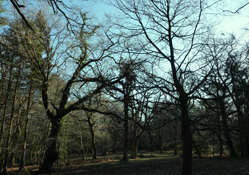
So, we are now within the Coppice of Linwood. Enclosed back in 1775, it was planted mainly with oak and beech, though conifers were added in the 1920s (in the north of the Coppice, above where we are walking), and then again after the Second World War. Joan is walking beneath deciduous branches, whereas I am aware of conifers mingling amongst the broadleaf trees. Much of the Coppice is, however, still classed as ancient semi-natural woodland, and the Forestry Commission has started a programme to fell conifers and restore the wood to a more natural state, which is a good thing. Joan finds that “the wood has an unkempt air…with a curiously deserted look about it as though no little beasts made their homes among it.” She loves, though, the moss, ivy and ferns that grow around and up and even in the trees.
One oak, growing tall and straight as a lance before its branches begin, wears a shoulder-knot of ferns in the fork of one of them.
I agree with Joan that the wood feels unkempt, but to my mind that’s just how any wood should be: all tangles and twists, higgledy branches, dark corners and sudden sunlight, dead wood and scurrying noises beneath the leaf litter. I see a memory in the soil: about half-way between the gate and what is now the cycle track running round the Coppice, I find four raised parallel ridges travelling along, covered with moss and lichens – the imprint of an old track. This must be Joan’s path. “Of course it is”, she smiles.
Under the cover of the wood I am finding the air slightly warmer, but it must still be close to zero. This means the ground is all icy bogginess. Mostly the frozen surface supports my feet without too many ankle twists, but every so often there is a squelch and my boot sinks a few inches. I am quite glad therefore to emerge onto the well-gravelled cycle track that loops round the Copse. There are miles of dedicated off-road cycle routes across the Forest, but they are a more recent addition so, while Joan keeps walking straight ahead without looking left or right, I pause for a moment to enjoy the sweep of the track as it twists downhill and out of sight.

Then I follow Joan, Bill and Mr. Bundy, but this time onto a clear (but still icy-boggy) path. A deer to the right glances across, and a woodpecker drums as a magpie flies by. My path ends up in the same place as Joan next describes: a meeting with another track (gravelly for Joan, muddy for me) with two bridges crossing two friendly little streams (called gutters). One bridge is wooden with a handrail, the other is flat and covered in vegetation. The second is the one we take, and we all walk along a stony-mossy ride. We cross the cycle track once more and walk on past the rather shabby remains of cleared conifers interspersed with young larch trees, just showing their early buds, before rejoining the cycle track just before the exit from the Copse.
King’s Garn Gutter
The gate marking our exit from the Coppice of Linwood is graced by some wonderful Scots pines. We emerge onto the wide ride that separates the Coppice from King’s Garn Inclosure.

Here, I part from Joan and the dogs for a while. They head off round Brook Common and the golf course: this is the Forest Course owned by Bramshaw Golf Club and is Hampshire’s oldest golf course, no less (originating around 1865). The course is on common land, so golfers mingle with ponies, pigs, donkeys and cows. The club is closed during the COVID lockdown, and I am surprised to see only one pony taking advantage of the quiet to munch on the lawns.
While Joan heads off, I continue eastwards along King’s Garn Gutter (which is fed by the two small streams we met with their bridges in the Coppice of Linwood). I ford the Gutter and then follow along its north bank. There’s no path here, so it’s a bit of a scramble, but from time to time I emerge on to the edge of the golf course for a bit of easier walking.

Joan calls this “one of the loveliest wooded bottoms in the Forest”, and she’s right. It winds its way between steep little banks full of roots, moss and ferns. There are tangles of thorns and fallen twisting trees. At a few points, miniature waterfalls have frozen in the cold and translucent ice sculptures have formed around leaves and branches dangling over the water. Eventually, the Gutter and the golf course’s edge combine and the stream twists onward, its flow slowing, criss-crossed by little footbridges. To the south, the marshalled trees of King’s Garn Inclosure gather just beyond the Gutter’s edge.
At the eastern edge of the golf course, I turn northwards up an oak-framed gravel track. To my left, scrubby Brook Common is full of noisy woodpigeons. I meet up with Joan and the dogs where the track turns sharp right just below Sker’s Farm, from where cows are lowing mournfully. We follow the road south towards Upper Canterton (which Joan calls Canterton), crossing a ford via a footbridge on the way.
Canterton and the Rufus Stone
Upper Canterton is a neat little village surrounded by fields, with some nice houses. A cock crows to emphasise the farming feel, and a pair of collared doves coo together. Joan isn’t so enamoured, though she admires some handsome pines. The big tin Dutch Barn she sees by the side of the road is no longer there, unless it is the barn conversion I pass (unlikely, as the conversion was definitely not made of tin).
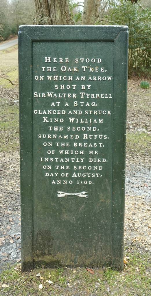
There is a well-known pub in Upper Canterton, the Sir Walter Tyrrell, named after the man who allegedly killed King William II (William Rufus, so called for his red hair) in 1100 on the site now marked by the nearby Rufus Stone. The pub was rebuilt in the 1930s, so I’m not sure whether Joan sees the new building or the original, which in my time stands derelict to its side. It looks inviting. As we were in lockdown, however, I couldn’t pop in for refreshment, much to the dismay of my tired legs. On, therefore, we walked to the Rufus Stone.
The designation of the New Forest as a royal hunting ground was down to William Rufus. The locals hated him for riding roughshod (pretty much literally) over their traditions and rights – he was also very unpopular nationally. His death and the location of it (if the story is correct in all details, but it’s a good tale anyway) was accidental or deliberate: if the former, then an arrow fired by Sir Walter hit an oak, bounced off, and fatally wounded the King. The knight fled in fear of his life, so the story goes, leaving the King’s body to be found by Purkis, a charcoal burner, and transported to Winchester on his cart. The Rufus Stone was originally set up on the site of the unwitting oak in the later eighteenth century. The cast iron cover with its inscription we see now was added in 1841 as protection for the stone which had suffered some vandalism.
Joan spends some time leaning against the stone, imagining herself there at the moment of William Rufus’s death.
…one can…see Sir Walter take hasty aim, hear the angry buzz of the bowstring, watch the arrow leap away, glance off an oak, and speed straight to the heart of the king.


Long Beech Inclosure
Joan heads off in a southwesterly direction towards Stoney Cross, the dogs and I in tow, along “a rutty path across the hillside”. This is marked as a proper track on the 1930s map, but on the modern map is shown as a footpath eventually meeting the gravel cycle track running adjacent to the A31. In reality, the footpath is invisible. The hillside is grassy and open between patches of gorse scrub and, on this thaw-less day, the frozen moisture underfoot is like an ice rink. I wonder if this icy layer is obscuring the footpath, though I don’t think so.
In any case, we soon reach a clear track (a birch-lined cycle track for me) and walk until it reaches its closest to the busy A31, a road that looks very different to Joan. In the 1930s it was unfenced (it was fenced in 1962) and was a single carriageway (it was dualled by the mid-1970s). In the 1930s, therefore, Joan and the dogs could with comparative ease have crossed the road to Stoney Cross had they wished. I cannot cross (and nor would I want to). The traffic roar is unnerving. I can just about see the Stoney Cross Travelodge, housed in the same building as the Compton Arms Hotel of Joan’s time. Joan also mentions Dick Turpin’s Cottage, which was a tea room and guest house in the 1930s: I believe the cottage has since been demolished.
We head northwards and downhill across the heath and along the footpath towards Long Beech Inclosure. On the way, we pass through a holly grove in the midst of which a single crab apple tree holds court.

Like the Coppice of Linwood, Long Beech was enclosed in 1775, but has suffered much less from subsequent conifer planting, and oak and beech – Joan’s “lovely old trees” – dominate. The footpath, still marked on the modern OS map along broadly the same route as Joan’s, has become overgrown to the point of disappearance – yet another vanished path. I track the route using the red arrow on my phone app, while Joan, Bill and Mr Bundy walk along their path until we cross pretty Coalmeer Gutter, the waters of which are a cold silver over the gold of fallen beech leaves. Beyond Coalmeer, the path remains hidden. The red arrow takes us across a clearing and into more trees, until we eventually meet a concrete track that takes us back towards Janesmoor.
This walk felt really long and my legs were tired, but in reality it was only a little over five miles. Maybe the cold, and in particular the need to be cautious in treading over the icy ground, challenged my stamina. I was glad to return to my car, where a donkey stood under the gorse soaking up what little warmth could be found, and looking at me balefully. Nonetheless, I really enjoyed walking in Joan’s company, beneath the trees and across the heaths, listening to her tales and learning some of the history of the New Forest.
Next week will be a shorter walk, though, in search of an ancient oak.


What a delight to be able to share your walks, you are such a keen observer and bring details to our attention that we might otherwise have missed. I love the old place names and the history is fascinating.
LikeLiked by 1 person
Thank you, Roger. I love old place names and history, too, and I’m learning so much from following your aunt’s walks.
LikeLike
Really lovely
LikeLiked by 1 person
Thanks – it was a lovely walk, if rather cold!
LikeLike