
In which I find a place where there was heathland, which became a wood, and which is now becoming heathland again
…we stopped on the brow of the hill to look at the fine bluff of Turf Hill and its pines, the ridge carrying the Fordingbridge road, Hampton Ridge and the intervening crest, and the mazy dance of hills still farther ahead.
Joan Begbie, Walking in the New Forest, published 1934
A few posts ago, I followed Joan Begbie’s bootsteps along a short section (through the bottom of Godshill Wood) of a long-ish circular route she took from Fritham in the early 1930s, passing through Islands Thorns, Ashley Bottom, Sandyballs (not yet a holiday village in Joan’s time), Godshill, Turf Hill, Black Gutter Bottom, and back to Fritham. That time, I left her at the edge of Godshill as she marched on to Turf Hill. I will do her whole walk from Fritham one day, if Joan and her dogs (Bill, a white bull terrier, and Mr Bundy, a diminutive griffon) can bear my company for the full twelve miles. For this post, however, I mapped out a shorter walk (four to five miles, depending on which way you go), joining Joan in a walk to Turf Hill, starting with our earlier walk through Godshill.
If you have a copy of Joan’s book Walking in the New Forest, then turn to pages 65 to 67 for Joan’s description of this short section of the walk (or pages 58 to 68 for her description of the whole circular walk starting and ending at Fritham). This walk is lovely in any season – from summer sun glinting on the brook to frosty, misty days of autumn and winter – but come prepared for muddy paths in wetter weather.
Back in May, Joan Begbie, Bill and Mr. Bundy and I set out to explore Godshill Wood in the north of the New Forest. I love this friendly, welcoming wood. Planted in 1810, it remains enclosed (although it’s not unknown for a pony or two to inveigle their way within its borders from time to time; I’ve never reported them – they always seem very content, and I’m no snitch). In her 1934 book Walking in the New Forest, Joan only wanders for a short stretch through Godshill as part of a longer circular walk from Fritham. I join her here; we mean to tramp along happily together from the wood down to Millersford Bottom and up to Turf Hill.
First, though, we enjoy the beautiful grassy way that runs along the southeastern edge of Godshill Wood, just outside its boundary. It’s here that I park my car, ready to set out on the walk.

Godshill Wood
We pause for a few moments, breathing in the fresh morning air blowing gently from over Godshill Ridge to the east (the ridge that carries the B3078), and to admire the blue skies, scudding clouds and wide views. We don’t want to leave that view behind, so we walk along the turfy way, passing by the first gate into the wood until, after a few hundred metres, we enter it by the second gate.
A path, sprouting with whortleberry and decorated with trailing ivy, meanders between tall oaks, pines and sweet chestnuts until it falls in with a ride.
Joan Begbie, Walking in the New Forest
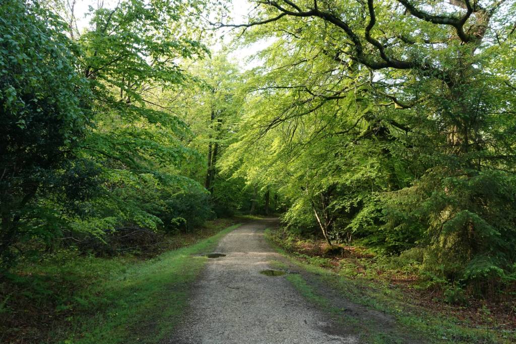
The ride Joan mentions is now one of the many cycle routes that run through the New Forest. However, you’re more likely to bump into dogs and their owners than cyclists here, so Bill and Mr. Bundy feel quite at home, with many new friends to sniff a welcome to. We turn right down the cycle track, a way I find particularly peaceful. It’s something about the gentle meandering, rise and fall of the path, and the comfort gained from trees bending down to greet you with soft brushes of leaves. There are side paths to take and explore – secret ways through the wood – but today we keep going until we reach the gate that leaves the inclosure by a foresters’ lodge, Godshill Wood Cottage. Just before we reach the lodge, we pass some forestry work sheds on our right, sporting a deer skull complete with very impressive antlers, greened with moss.

Godshill Wood Cottage 
Deer skull with antlers
At this point, Joan makes a remark with which I am going to have to take some polite issue. All residents of Woodgreen, put your hands over your ears. Joan points out that if we turn left after leaving the wood, we would reach Woodgreen, “a village with a charming setting but no architectural graces.” Really, I say? I think it’s a very pretty village, with some delightful cottages. I’m glad to report that Heywood Sumner agrees:
Wood Green is a beautifully situated village…Merry trees (black cherries), and orchards abound here, and the cottage gardens vie with those at Breamore as the gayest in the district.
Heywood Sumner, The New Forest, 1924
So, sorry, Joan, Heywood Sumner and I are not in agreement with you here. My fondness for Woodgreen was heightened by my experience there when I was attempting the Avon Valley Path from Fordingbridge to Downton on a very hot summer day, very soon after I moved to the New Forest. I got lost twice in Woodgreen (don’t ask) but was put back on the right track by very affable and chatty village folk who didn’t make me feel stupid because of my lack of any sense of direction.
Densome Corner to Millers Ford
Joan stands by her view, though, and we turn right, down towards Densome Corner. Joan says this way is a lane with “generous grass borders growing gorse and holly”. I’m not sure whether or not the lane would have been tarmacked in Joan’s time (as it is now), but it is otherwise much as she describes.
We reach Densome Corner and, as the road bends left, Joan is surprised by a donkey and carriage.
…a wondrous equipage rounded the corner, driven by a delightful lady. It consisted of a seat with back and dashboard, mounted on two motor-car wheels, whose balloon tyres made the smartly trotting donkey between the shafts appear more slender than he was. A gentlemanly greyhound brought up the rear.
Joan Begbie, Walking in the New Forest
I really wish I could have seen this wonderfully eccentric carriage and its driver, too. However, on we go, leaving the road and heading off to Millersford Bottom. The view from the top of the hill here is wonderful, looking towards Godshill Ridge and Deadman Hill, and beyond. There’s a gang of cows at the latter, and we can hear them lowing even from our vantage point here on the opposite side of the valley.
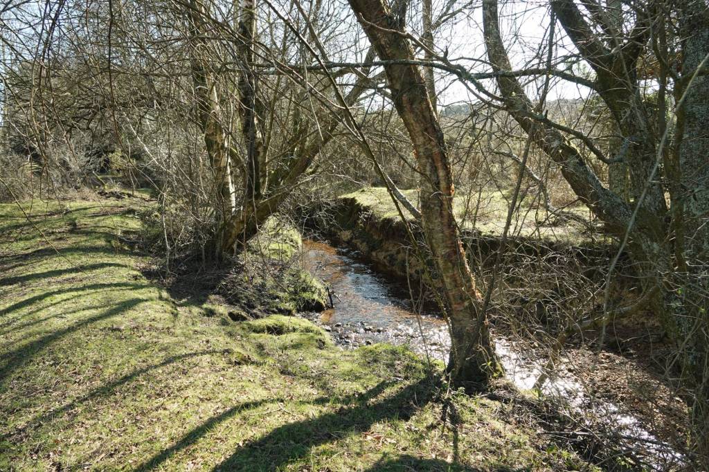
We navigate crossing the brook, which is as delightfully chuntering as you’d expect a New Forest brook to be. The ford itself was apparently once a crossing point on the route southwards from Woodgreen and Breamore Mill. Then, we turn left to climb up Turf Hill to the top of the plain.
Turf Hill Inclosure
I headed this post A changing New Forest landscape, and here is the reason why. Although Joan mentions pines on Turf Hill, these to her eyes would have been very scattered asin the 1930s, in fact, she and her dogs are climbing up and walking across open heathland.
I’ve been used to describing inclosures and plantations as created in the eighteenth or nineteenth centuries. Turf Hill Inclosure was, however, planted with its pines in the 1960s, three decades after Joan walked along its slopes and high plain. It’s what is known as a Verderers Inclosure. The ability to create these was legislated for in section 12 of the New Forest Act 1949, by which the Verderers were able to authorise inclosures and then rent/lease them to the Forestry Commission, as compensation for loss of grazing. (Find out more about the Verderers of the New Forest on their website, and the New Forest Explorers Guide website gives a good explanation of the history of inclosures in the New Forest, ending with the 1949 Act and Verderers Inclosures.)
But the change doesn’t end there. The Forestry Commission is now in the process of restoring quite a large part of the eastern portion of Turf Hill Inclosure back to heathland. Walking west to east, as we are doing, after leaving the Inclosure’s trees you first come to an open landscape that looks a little barren and post-apocalyptic; there are large areas where pines have been clear-felled, branches and twigs left to lie on the ground, and the occasional pioneer birch sprouting forlornly. There is much bracken here, too.
An area of clear felling in Turf Hill Inclosure. The few birches look rather forlorn, but the felling is all part of a Forestry Commission plan to return the area to heathland, as it was only a few decades ago.
But life is already blossoming, nature as resilient as ever. On the stumps of felled trees, fungi and lichens are gaining a hold, watched over by heather and nodding grasses.

A little further eastwards, the landscape becomes much more heath-like, if quite scrubby: Ling and Bell Heather in friendly huddles, Gorse and grasses, and even a Rowan already bearing its lovely red fruit. This eastern section was cleared earlier, and is therefore further along the route to becoming heathland again. I wonder what it will look like in twenty, fifty, or a hundred years from now. I hope the vision will be realised, and Turf Hill will once more be a wide, breezy, heathland plain with views south, north, west and east, just as when Joan walked across it in the 1930s.

We’re approaching what is now the Turf Hill car park, and it’s time to part from Joan, Bill and Mr. Bundy as they head off for Black Gutter Bottom. I wave farewell, and promise I’ll walk that way with them soon.
Before leaving Turf Hill, I pause to admire some Rowan berries, already gleaming red even though it’s still August, and make friends (from a distance) with an old Crow, feathers white and ragged round its neck, dabbling in the grass a few paces away.

Millersford Plantation and Copse
There are a few ways to return to the Godshill car park. You can head southwards and westwards, on tracks heading towards Deadman Bottom and Cunninger Bottom and then strike up to Millers Ford and walk back along Millersford Bottom or adjacent paths. Or you can do as I did, and head into Millersford Plantation and Millersford Copse, rejoining the return route at Millers Ford.
Millersford Copse, to the west of the Inclosure, is an older part of the wood. The newer plantation of Oak and Scots Pine absorbed the Copse when it was created in the first half of the nineteenth century. Unlike most other plantations, however, it was not part of the Crown lands – the plantation was on land that was originally part of the adjacent Hale Purlieu, and purlieu means land not subject to forest law. It came into the ownership of the National Trust just after the Second World War, who leased it to the Forestry Commission, who planted with conifers. (Credit for this brief description goes to Antony Pasmore’s wonderful series of New Forest Notes: I got the information on Millersford from the April 1999 edition).
Whatever its history, or probably because of it, this is a wonderful wood, full of surprises. A friend and I, walking there in autumn, found an old Sweet Chestnut that must have been coppiced in its past, and now sports several trunks, branching out to the sky like the tail of an upside-down comet. In autumn there are fungi on fallen trees, and there is a steep-sided brook.

Back to Godshill Wood
At Millers Ford, there is no need to walk back up to Densome Corner; I continue vaguely westwards (there are a few more paths trodden in than are shown on the map), until I reach Godshill car park. I spend a few minutes there, gazing at the view, thinking about how landscapes change: through human management from prehistory to modern forestry, such as at Turf Hill Inclosure; through seasons, as summer turns to early autumn and the first berries appear; and through life and death, youth and senescence, as fungi grows and thrives on a fallen tree, and an old crow, nearing its own end, grubs in the grass and watches me with knowing eyes.


Hi Amanda, I am putting together a website with before and after photos of the demolished trees, along with aerial photos from 1951 and a map of successes/failures at heathland restoration. There will be a short segment explaining the history of the Turf Hill and Millersford inclosures. Since you were instrumental in pointing me towards Anthony Pasmore, would it be OK if I reference and give credit to your blog please? Thank you.
LikeLiked by 1 person
Hi Naomi – of course, that’s fine. Thank you for asking.
LikeLike
Hi Amanda, I hope 2023 is starting off well. Its taken 6 weeks, but we have finally finished our website that discusses Forestry England’s management of Turf Hill, Millersford, and Hale Purlieu. It includes before and after photos of the damage and destruction and failed heathland caused by clear felling in these areas in the past 20 years. Plus maps, aerial photos, and questions I submitted both to FE and National Trust. I have linked to your blog in the history section of the website. A 1927 speech made in the House of Lords by Lord Montagu of Beaulieu may be of interest to you, I write about it in a blog post. Thanks.
https://halepurlieu.wixsite.com/newforest
LikeLiked by 1 person
Thanks, Naomi – I’ll take a proper look at your website very soon (I’m away for a bit, but back end next week). It will be interesting how FE and NT respond to your questions. The 1927 speech sounds intriguing!
LikeLike
For those who want to see the destruction for themselves, access may be limited during the week due to heavy machinery/forestry operations. Forestry England has a board at the Turf Hill and Roger Penny Way car parks with a brief explanation and diagram of their future plans, including further proposed demolition. They note ‘questions or comments relating to the works’ can be directed to: southern.enquiries@forestryengland.uk Note: these boards have only appeared in the past several weeks, probably in response to complaints. NO advance notice of the felling was provided AT THESE CAR PARKS last year. I am inquiring to see if advance notice was given at previous meetings that the majority of the public were unaware of. I have photos of next phases of their deforestation project, that appear on the boards in the car parks.
LikeLiked by 1 person
Hi Amanda, I just left a very long comment, with a LOT of information about historical use of this area, info from aerial photographs from 1951 onwards, and a 5 hour survey we did yesterday to analyse both what species of trees were felled, and the success or failure of heathland restoration at Turf Hill. I don’t know if it will show up or you consider it too long. I wanted to let you know that I ordered Joan Bugbie’s wonderful book on Saturday, it arrived yesterday, and I stayed up late last night reading it! To my surprise, it has been reprinted from a new publisher, so it was a new copy. Thank you for your fantastic blog, and introducing me to Joan Bugbie. I look forward over the next year to tracing a lot of your walks, and reading your blog.
LikeLiked by 1 person
Thank you, Naomi. Joan Begbie’s book is wonderful, isn’t it, and interesting that there’s a reprinted version. I may get hold of that, as my 1930s copy is starting to look a bit careworn. I’m really glad you enjoy the blog – I love writing it, and following in Joan’s footsteps (and the paw prints of Bill and Mr Bundy, of course).
Your previous post had gone into my Spam – WordPress will have judged it on length, not content – so I’ve now approved it, so it is showing below. That’s a brilliant and detailed piece of fieldwork and research you’ve done – I’m in awe! I haven’t visited the area for a few months, so haven’t seen the extent of the deforestation. I’ll go along and take a look in the next week or two. Have you thought of sending any of your analysis directly to Forestry England? I will certainly get in touch with them after I’ve been along.
LikeLike
For those who want to see the destruction for themselves, access may be limited during the week due to heavy machinery/forestry operations. Forestry England has a board at the Turf Hill and Roger Penny Way car parks with a brief explanation and diagram of their future plans, including further proposed demolition. They note ‘questions or comments relating to the works’ can be directed to: southern.enquiries@forestryengland.uk Note: these boards have only appeared in the past several weeks, probably in response to complaints. NO advance notice of the felling was provided AT THESE CAR PARKS last year. We have obtained aerial photographs of Hale Purlieu/Turf Hill from 1951, 1985, 2002, 2005, 2014, 2017, 2018, 2020, 2021, 2022. From this we were able to produce a map showing what areas were cleared when. (We can post this map if people are interested.) We took this map with us yesterday and for five hours did a full survey of the site taking many photographs, documenting what types of trees were felled, and importantly, noting the success or failure of attempts since 1985 to restore heathland where trees have been felled. As a result, three of the biggest claims made by Forestry England are entirely false. We estimate 70-80% of the trees that were removed, by far the most dominant species, WERE NATIVE SCOTS PINE. Scots pine is unique and easily identifiable both close up and far away, its needles are far shorter than other pine, and the upper half/third of the tree has a beautiful orange brown colour to the bark. These trees were all over the hillsides and filled the lower areas along the stream at Millersford Copse/Plantation and Turf Hill. They are tall and their orange brown bark can be easily seen even from the horizon. These are the same trees that Scotland is replanting in their thousands in efforts to restore the ancient and once extensive Caledonian pine forests, and the main feeding and breeding source in southern England for the Pine Hawk Moth. Scots pine thrives in heathland. It creates important ecosystems and supports a lot of wildlife. Insects find shelter in the deep fissures of the bark, and lichen is able to fix nitrogen from the air.
Other trees that were felled include pine with longer needles, which I assume were not native, and at the bottom of Turf Hill towards Millers Ford, beeches, oaks, and birch were felled. These hardwood trees were in the minority and in a smaller area, but they were beautiful, big mature trees. I have photographs, they are easily identifiable. One small group of trees has been retained along the ridge, from the January 2023 felling, these trees are mainly hardwood with a few Scots Pine. It is important to note that Phase 2 of the proposed work, to be completed starting 2026, would remove a significant number of native trees if the areas are clear felled as all previous areas have been. Native birch has filled in the majority of this area, and oaks are also present. The walks through here are beautiful, with the reddish tops of the birch trees visible at a distance even in winter gloom.
Regarding heathland restoration, which is the stated goal by Forestry England, an analysis of intent vs outcome leaves a sorry story. Areas cleared 1985-2002 have regenerated fairly well with heather, except several years ago a section of the 1985 heather was burned (misguided ecology?!) and has not regenerated. It is now just grass with burned twigs. Another section from 1985-2002 to the NW (where all the cut logs are now piled) has failed, with just bracken and turf grass remaining. With just one exception, all other areas felled from 2002 onwards have failed, (ie the majority of the entire plantation) leaving only bracken, baby gorse plants, barren gravel/soil, moss, or turf grass. The soil is clearly poor. Bracken is poisonous to browsing animals, and the New Forest burns gorse, although every winter we do see the animals eating it. I am not aware of any effective program to remove bracken, once it is established I believe it will always be dominant. The heartbreak here is that a species that was so clearly valuable to anyone (ie, trees!) would be replaced with bracken, gravel, gorse and grass. The second heartbreak is that visitors to the area are now asked to tolerate a scarred, barren landscape in the hopes that in 20 years, perhaps a desired species will become established, although probability remains low. The third heartbreak is that an institution such as Forestry England would not undertake, or care to undertake, on an analysis of their past success at heathland restoration, before embarking on removing an estimated 15 hectares (37 acres, estimated area of trees felled in January 2023) of beautiful trees and ecosystems and thereby continuing their failures. !!!!
The third stated goal by Forestry England to ‘clearfell’ is because ‘selective felling’ is impossible due to the exposed terrain. Ie, wind would knock over any trees that they would leave. I dislike disagreeing with such a venerable institution, however all evidence at Hale Purlieu proves contrary. A row of pine trees were retained along the very peak of the exposed bluff of Hale Purlieu, from felling undertaken 2005-2014. I assume the trees were retained to block views of the power lines and pylons, which are dominant here. These pine trees remain, standing tall and strong, despite being the most exposed for several miles. I compare this to the woods adjacent to Woodgreen. Despite these woods being dense, not exposed, but protected by other trees and the terrain, every winter many hardwood trees fall over and block the trails. Anyone who has visited mountainous terrain has witnessed the hardiness and tenacity of pine trees and their ability to cling to steep slopes and the smallest rocks.
So that addresses the claims made by Forestry England. Now to consider historical use of this area. What I know of this is solely due to Amanda in her blog above, who refers to Joan Begbie’s book ‘Walking in the New Forest’ and Antony Pasmore’s New Forest Notes, April 1999 edition. Mr Pasmore writes the following: ‘Unlike many other Forest woods, we have a detailed picture of what Millersford looked like in the 1890s. This was written by the landowner of the time. He records the layout of a great drive through the plantation and attempts to introduce evergreen oak and rhododendron made about 1870 “but with scant success”! Some of the oaks survive to this day. His description of Millersford Copse (a sub-division of the plantation) accords well with the character woodland now emerging in the wake of the diggers and which promises to become one of the most attractive spots in the north of the Forest. Millersford Plantation has a curious history. Its exact origin is not known but it was almost certainly enclosed out of Hale Purlieu between 1826 and 1830 and is thus contemporary with many of the Forest’s Inclosures. However, it has never been part of the Crown Forest. Just after the last war it was given to the National Trust who promptly leased it to the Forestry Commission to plant with conifers. Now there are plans to restore much of it to its pre-1830 condition.’ Mr Pasmore writes in 1999 of a ‘massive programme’ to eliminate rhododendron from the two adjoined woods of Turf Hill and Millersford Plantation, which had the worst ‘infestation’ in the entire Forest. This program transformed Millersford ‘ from a dark jungle, accessible only on narrow muddy paths, to delightful open woodland.’ From all my walks through this area the past 8 years, I can attest it was indeed still delightful open woodland, filled only with ferns. Joan Bugbie, writing in 1934, describes ‘the fine bluff of Turf Hill and its pines.’ She writes that Telegraph Hill is ‘easily recognizable by its belt of pines.’ Joan also writes of the ‘heathery plain on top of Turf Hill.’ To this written history, I add aerial photography from 1951, which shows Hale Purlieu, Turf Hill and Millersford almost entirely barren, with the exception of some original trees (noted to be removed in Phase 2 of Forestry England’s plans.) Scars from aerial bombing practices can be clearly seen, the New Forest was turned into target practice. When I add all this together, I come to the following conclusions: that this area was heathland to 1830 when it was enclosed and planted. Joan Bugbie attests that pines were present in 1934. At some point it was deforested, then replanted with conifers by the Forestry Commission in the late 1950s/early 60s. By 1985 the conifer forest was extensive, extending to the NW just beyond the power lines, and to the east surrounding the old gravel pit and almost to the Turf Hill car park. The pine planting was a resounding success. This forest was so valued that much money and effort was spent in 1999 to remove invasive rhododendron and open up the forest floor. This all leads to several questions! If Millersford Plantation is contemporaneous with other New Forest Inclosures, why the determination to completely remove it? Why the insistence to ‘restore’ it to 1830?? Why are other Inclosures not being ‘restored’ to their unplanted, heathland status? Perhaps because the outcry would be immense?! If the trees have existed for 60 years, why are they being removed NOW? And why is the heavy handed management of Hale Purlieu, so clearly different from other areas of the Forest?? If anyone else has further historical data they can add to my knowledge of Hale Purlieu, Turf Hill, Millersford Copse and Plantation, please let me know! A photograph or picture is worth a thousand words!
The only argument with any viability for the destruction of such beautiful trees is that the Forestry Commission leased the land from the National Trust, paid to plant the trees, with an expectation that at some point in the future they would be harvested, and profit derived from the sale of the timber. My response would be to ask how much profit has been obtained, vs. the huge labour and cost to remove the trees, the destruction of both habitat and trails, and the amenity lost to the public. A lot changes in 60 years, including people’s views on the value of trees. As every decade more trees have been removed at Hale Purlieu, more precious the ones that remain have become.
When we returned home yesterday after our 5 hour survey of Turf Hill and Millersford Plantation, I heard the one thing I had not heard all day – birdsong. All I heard all day yesterday was road noise from Roger Penny Way. Several people living in Hale noted that traffic was louder now the trees are gone. Our garden with all its trees and shrubs is filled with birdsong all day, even in winter. Turf Hill is now silent, except for cars. When we first saw the destruction on Friday evening, one owl hooted. I wondered if his home would soon be gone too. One Hale resident noted that the deforestation combined with their 2018 National Grid underground powerline proposal fight, made her ‘want to move away from the area.’ She expressed ‘weariness about fighting.’ Another visitor was ‘apoplectic with rage’ when he viewed the destruction. Another person I talked to said that for local residents, the 2018 underground power line fight was about property values, about not having a power cable going through their back gardens. He suspected that regarding the deforestation of Turf Hill and Millersford Plantations, since it was further away, people may be more apathetic in their response. Well, Phase 2 of the deforestation will be closer to homes. When those trees are gone, more traffic from busy Roger Penny Way will be audible. The power pylons and cables will be fully revealed in all their glory. Hale Purlieu is the north gateway to the New Forest. Tourism brings a lot of money to the area. Do visitors really want to see a tree cemetery and ruined trails when they come here for their holidays?
My final note is this. We have lived here, and enjoyed the New Forest for 8 years. In that time, we have only ever seen things being taken away. Access reduced, ditches, literal trenches dug and bollards installed to stop parking, trees destroyed and felled, gorse and heather burned. In our northern half of the New Forest, we have not seen ANY investment. No new car parks, no extension of car parks, only one occasion we are aware of that a car park was repaired and resurfaced, no new trails built, no bridges over streams that may give access to families, (ie, people not on horseback!!) and most importantly, NO REPLANTING. This is a sorry state of affairs. Everything we have observed, and most especially the destruction witnessed the past 3 weeks, have removed any desire to volunteer or invest in the Forest. We have decided the only way to cohabitate with the actions of Forestry England, and the management of the Forest, is to NOT CARE. Because to live next to the Forest and care, is to be continually upset. We too, are wondering if it is time to move away. If the managers of the New Forest want future generations to become invested, this is not how to go about it.
Please feel free to forward or pass on my comments, but please give credit to ‘Naomi Hoffman.’ I intend to contact National newspapers to see if they would write an article on the Forestry England deforestation project.
LikeLiked by 1 person
Hi Amanda,
I am also a local resident and sadly, I agree with Naomi. I came across your article as I was searching for some reason behind the destruction. I wondered if it was the need for wood for the building industry. The area is totally devastated. In this era of being more aware of climate change and the importance of trees, nature and wildlife I don’t understand how the forestry commission or natural trust could allow this to happen. In the past I have lead groups of friends on similar walks but would now be ashamed to share the scenes of destruction.
I understand that is is important to have areas of heathland but if an area has changed decades or hundreds of years ago to forest, who are we to destroy the habitat of the current inhabitants of the forest?
LikeLike
Hi James – I will take a walk there in the next week or so to see for myself. What I’ll then probably do is email the Forestry Commission to ask them what’s going on, and I’ll post back in this comment thread. It may be worth you getting in touch with them yourself, too – if they know of local concern it might prompt them to communicate what they’re doing, and why!
LikeLike
Hi Amanda, this article and your blog are delightful, beautifully written. We live locally, and did this walk today and was left speechless by the devastation left in the wake of deforestation done in December 2022. As you write, it was barren and post apocalyptic before, there are hardly words to describe how it looks now. A scene of total devastation and demolition. The Turf Hill and Millersford trails are not even passable. They are deeply rutted and tracked mudpits. Trees and branches are strewn everywhere. The Millersford route with the tall trees either side of the trail used to be like a natural cathedral, now all gone, trees strewn about like a tornado has come through. Acres of land not even passable for the horses, humans can’t make their way through the debris. Sunlight coming through the trees and touching on ferns in the understorey on Turf Hill was serene and sublime, such a joy, now all gone, desecrated. There are zero benefits to violent clear cutting like this. Apart from the loss of beauty and amenity, I grieve for the lost habitat and shelter for the birds which once roosted in these trees. Based on their rejection of the National Grid plans for Hale Purlieu in 2018, the RSPB would certainly not approve. Based on its SSSI and National Park status, how this was even legal I don’t know, homeowners have many hoops to jump through to remove even ONE tree! The areas clear cut a decade ago have still not regenerated and as you note, are still an eyesore. I don’t know who was responsible for this, either National Trust or the Forestry Commission, but I doubt the parties responsible will restore the trails. Visitors to the North New Forest will now be met with a scene from a natural disaster movie. It will take 20-30 years to regenerate. 😦 I am interested to read your comments when you get the chance to see this area again soon.
LikeLike
Oh goodness – I haven’t been to Turf Hill and Millersford for a while, but this sounds awful. I will aim to get there soon, to see for myself. As far as I’m aware, this is Forestry Commission land, and from their forward planning documents, it is their intention to return parts of this area to heathland. I imagine regeneration takes a while, but I’m no heathland/forestry ecologist. But, whatever the arguments for or against that as a plan, it doesn’t mean the area should be left in an impassable, derelict state. Once I’ve been, and done a bit of digging (not literal digging!), I’ll respond to you again 🙁
LikeLike