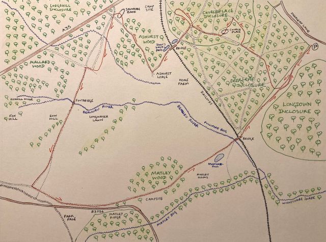
In which I continue a circular walk from Deerleap Inclosure, walking through woods, fallen leaves, and many watery, muddy bits
A track crossing the heath on the left led us through the enchanting outskirts of Mallard Wood, down into a wide heather bottom criss-crossed by waterways each bestrode by a bridge and bright with waterflowers…
Joan Begbie, Walking in the New Forest, published 1934
At the end of last week’s post, you left me in Ashurst Wood, just the other side of the railway track from Churchplace Inclosure in the New Forest. As always, I am following in the bootsteps and pawprints of Joan Begbie and her two dogs (Bill, an exuberant white bull terrier, and Mr Bundy, “a rough-haired brindled griffon of diminutive size and choleric disposition”).
We started our walk back at Deerleap Inclosure, walking through Churchplace Inclosure to arrive at the borders of Ashurst Wood. When Joan originally walked this way, as she describes in her 1934 book Walking in the New Forest, it was spring. Now, here we are on a late autumn morning, muddy in parts and crunchy with fallen leaves underfoot. However, the sun has come out after a mizzly start, and the sky is that hazy blue peculiar to this time of year.
If you have a copy of Walking in the New Forest and want to read about her circular walk (which she began at Pig Bush in a much longer, thirteen-mile walk, but which includes a good part of the walk I took), then turn to pages 216 to 228.
Ashurst Wood and the saltpetre house
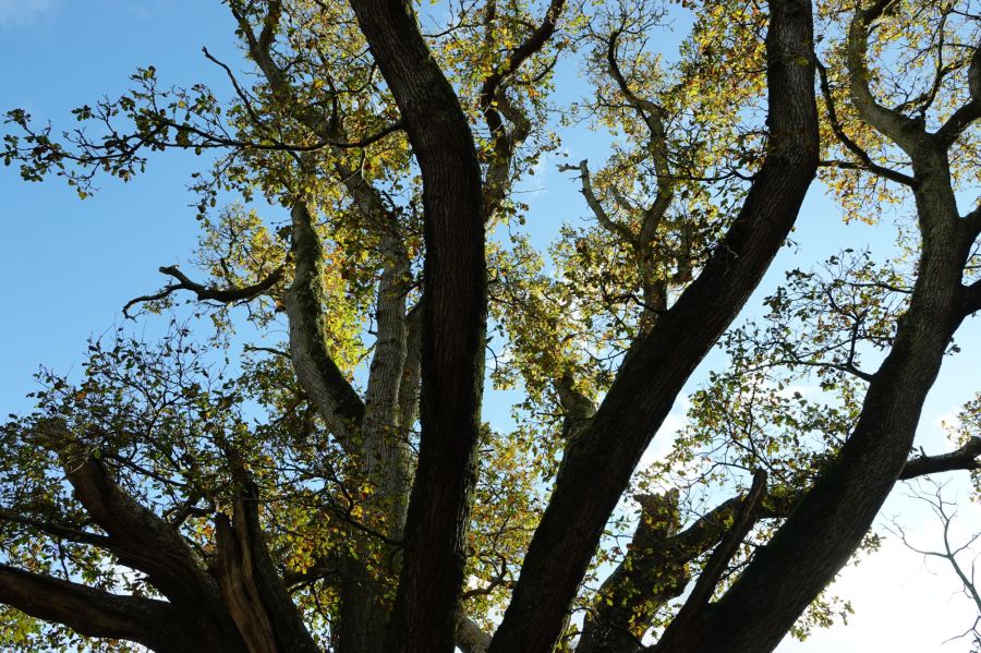
Ashurst Wood is a welcoming place. Crossing the railway bridge, oaks gleam in bronze, their branches beckoning as they wind and twist towards the sky.
The name Ashurst means ash-wooded hill, and while I can see no Ash trees, this is definitely a hill with a wood. We are walking towards Ashurst Lodge on a path patched with friendly old cobbles. The Lodge site originally dates to Tudor times, when it was the residence of the Master Keeper of the East Bailiwick (Bailiwick being an ancient, and now superseded, division of the New Forest). The current building is of a later date and is occupied by the Wessex Institute of Technology; we don’t go to take a look (see the Ashurst and Colbury Parish Council website for some interesting information about the history of the local area).
Instead, we turn north-westwards when we meet a minor tarmacked road running down to Ashhurst Lodge and nearby Home Farm from the A35. To our left, we can see through trees to the grassy plain beyond. It is called Old Ralph Heath on the Drivers’ map, both the 1789 and 1814 editions, but not named anything on the modern OS map. Who was Old Ralph, I ponder, and would he regret the loss of his name from printed memory? Our feet and paws, however, keep us to the flickering sunlight of the wood. Small birds flit from tree to tree ahead, and a Redwing eyes us from the safety of a high branch. We pass a Beech and Hollies clutching each other tightly, with the Beech sporting a row of curious knobbles along its base.

A little further, and a Holly has shed its berries along the edge of the road in a carpet of red jewels. We are careful not to tread on them, for fear of spoiling both their beauty and their potential as food for birds and small forest creatures.

As we approach the northern corner of the wood, we turn from the road and into the wood to find the site of a saltpetre house (marked on some older maps as saltpetre bank). Saltpetre (which is mainly formed of potassium nitrate or sodium nitrate) was manufactured in Tudor times (from about 1560) for gunpowder and for tanning of leather. I found out some more from an issue of the Hampshire Field Club’s Archaeological Notes, as follows. Saltpetre occurs naturally in some soils, and its production focussed on either extracting it from the soil or making heaps of organic matter, mixed with lime, to stimulate its formation. It was extracted using water and adding potassium carbonate or wood ash (trees from Ashurst Wood were used for this here).
All that is left now is a series of banks among the trees, and I stand there for a while, leaning against a Beech, appreciating the breeze and the bird calls. I ignore the traffic noise from the A35, which seems a distant overlay from another age, while I have slipped into an earlier time for a few moments.
The Salt Way
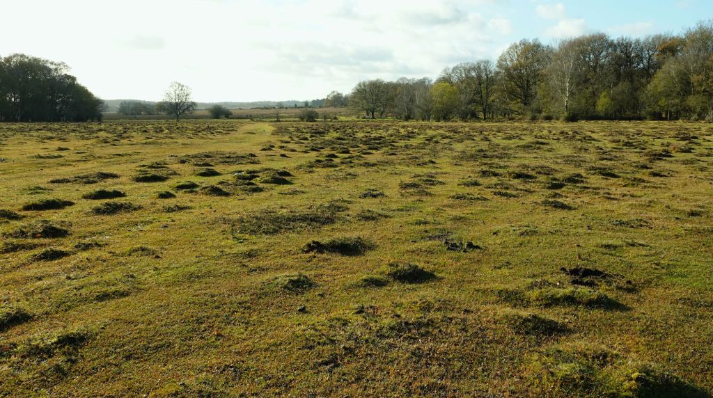
From here, we turn southwards over the heathy grassland, bumpy with its many little hummocks. What are they? I listened to a talk by Clive Chatters (the New Forest-based author and naturalist) earlier this year, who explained there are two schools of thought: they are either caused by mounds of silt trapped by floodwater, or are created by Yellow Meadow Ants, or both causes could be at work, with silty mounds encouraging occupation by the ants. I did meet someone once who thought the hummocks looked just like the trolls in the film Frozen: I like that idea very much.
Joan and the dogs stick to the path here, but I walk a little to its east for a while, picking my way across streamlets and avoiding muddy patches as best I can. The way Joan is walking follows close to what is called, on older maps, the Salt Way. It’s not, as you may think, associated with the old saltpetre bank. This route is part of an ancient network of tracks used for the transport of salt inland from salterns on the coast, possibly since the Iron Age, until the nineteenth century. Find out more on the New Forest Explorers Guide website. As I rejoin Joan, Bill and Mr Bundy close to the eaves of Mallard Wood, I pause to think of the centuries upon centuries this way has been trodden. I wonder what those long-gone people thought as they walked here, not for recreation but for trade and livelihood. Were they tired or cold, heads down as they trudged along with their cargo of salt, laden on ponies and donkeys, cursing the muddy ground and many little streams? Or did they look up to the eaves of a wood older than ours, and take heart from its beauty?
Bill and Mr Bundy (especially the energetic Bill), however, do not approve of pausing to ponder. Bill leaps ahead into Mallard Wood, and Mr Bundy nudges at Joan and me to get a move on. So, we do.
Mallard Wood and the Beaulieu River

We don’t delve too deep into Mallard Wood. It is lovely, with its golden and bronze leaves glistening in the late autumn sun. Passing it by, we head south towards the upper reaches of the Beaulieu River, crossing it be a wooden footbridge. The river, here still a brook and not yet the wider river it becomes further east, winds and turns across Longwater Lawn. It reflects the clouds and blue sky above, and an old wayfinding stone sits near the bridge; I can’t read the inscription, though [but please see the response in the Comments section below – the stone is actually a boundary stone, not a waymarker – thank you to the commenter for the information and explanation of a fascinating tradition].

From here, Joan and the dogs strike out towards Bolton’s Bench, near Lyndhurst. I decide to cut that corner out, in a been there done that and my feet are already tired frame of mind. That’s not to say it’s not worth visiting. The Bench is a natural hillock on which yews grow, named for a previous Lord Warden of the New Forest, and it affords some lovely views. I stick to the Salt Way, until I meet the sandy path running eastwards from Bolton’s Bench alongside the Beaulieu Road (the B3056), a path that crosses the Park Pale you will see marked on the map; this is the old ditch and bank of the mediaeval boundary of a deer park. Here, I meet Joan, Bill and Mr Bundy again, striding down the track towards me after resting their feet and paws eating ice-cream at Bolton’s Bench.
Matley Wood and the return to Deerleap
Rested and refreshed we followed a broad sandy gallop running over the moors close to and parallel with the Beaulieu road. It began very soon to run downhill and when it got near the oakwood called Matley we left it, crossing the road and entering another track.
Joan Begbie, Walking in the New Forest
Our reunion is short-lived, though, as it is here that Joan, Bill and Mr Bundy leave me, as they are off down to Denny Wood and so back to Pig Bush, from where they started their longer walk. We wave each other goodbye (well, the dogs wag their tails), and Joan berates me light-heartedly for my lack of stamina in choosing a shorter route. It’s still seven and a half miles, I say. That’s quite enough for an autumn trek!
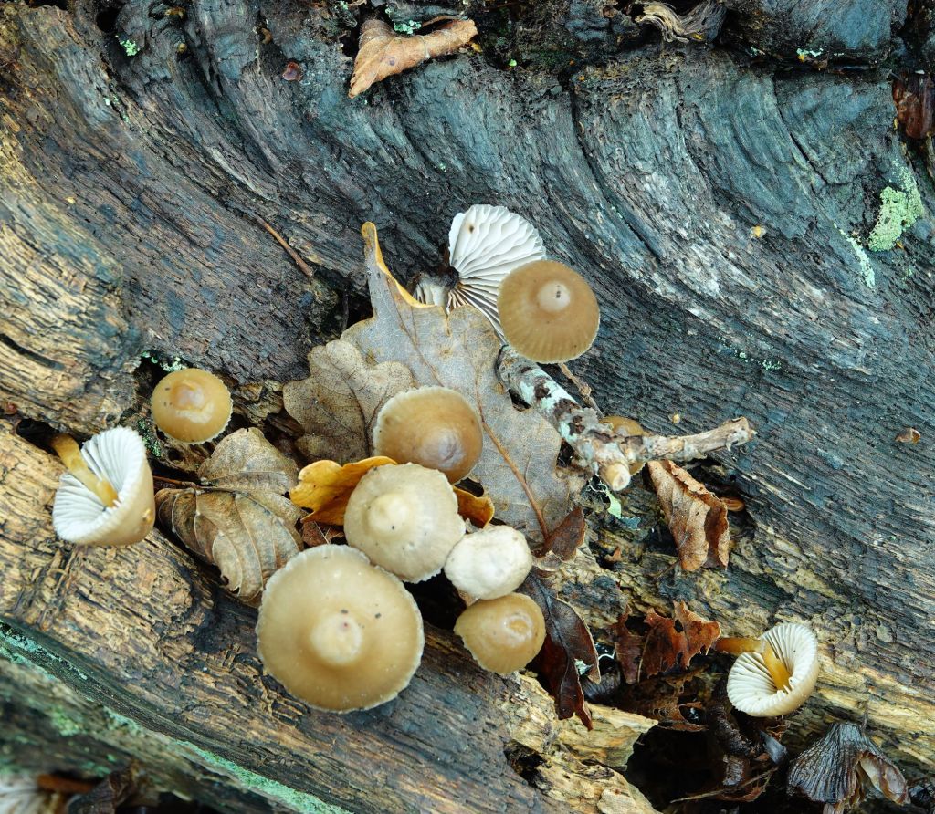
I head through Matley Wood, past the campsite. I’m stopped by two sparrowhawks having a go at each other among the trees before disappearing out of sight, so I’m not sure who won the battle. Matley Wood is a lovely deciduous wood, full of Oak, Beech, Sweet Chestnut, Holly and Ivy. There are many fallen trees and branches, part of a natural woodland system and which I find lovely to look at in all its gnarled and higgledy-piggledy glory. Some fungi are hanging on as autumn turns to winter; a few autumn leaves still cling to the trees, but many more crunch beneath my boots as I walk on.
Just before leaving Matley, I find an old pollarded Oak, some of its branches broken but others spreading in a circle of acclaim to the sky as the tree guards the wood’s edge. I place my hand on its ridged bark and enjoy the peace for a short while, before leaving its protection for the open heath.

A flock of Redwings skirts the wood’s edge. I don’t follow them, but head eastwards towards Fulliford Bog. On the way, I pass some red rosehips on my left, framed against the woods of Deerleap, and a large ephemeral pool to my right, before once more passing over another railway bridge. Now I am back to the path I took at the start of the walk, and soon arrive, tired but content, at my car.
I hadn’t walked in this part of the New Forest before, and I was delighted with what I found. The late autumn golds and russets against a blue sky more than made up for the few muddy patches and rough ground. I have a feeling this walk will be even lovelier in spring. I may return, and may even attempt Joan’s longer walk starting from Pig Bush. We’ll see!


Amanda; I thought I would mention that what you took, quite reasonably, as a way-marker is actually a boundary stone. It marks the boundary of Lyndhurst parish and, the then, Colbury parish – now Ashurst and Colbury.
If you zoom in with your photo, you might just be able to make out the word ‘Colbury’ amongst the crust of lichen. It’s possibly more obvious once someone points it out. Depending upon the time of year, weather and amount of light, sometimes the wording is clearly visible – at other times it is difficult to make anything out. I have a photo I took in bright sunshine one April that clearly shows the wording as ‘Parish of Colbury’. I’m not sure if anything was ever inscribed on the Lyndhurst face. Maybe it’s badly weathered or they simply never bothered to dress that side of the stone.
I believe Lyndhurst still conducts a ‘Beating the Bounds’ (or ‘Perambulating the Bounds’) every seven years or so where villagers walk around the entire boundary swatting boundary stones and landmarks with birch or willow switches. The idea being to commit the boundaries to community memory. The custom dates back at least to Anglo-Saxon times when maps were rare and certainly not accurate. In addition to preventing encroachment, it also determined who had to contribute to the upkeep of churches etc and who would be entitled to be interred in the churchyard. In one sense, its present-day equivalent might perhaps be joining the Electoral Roll and registering to pay Council Tax.
LikeLiked by 1 person
Hi Keith – I’m sorry I’ve taken so long to approve and reply to your comment – WordPress had put in the Spam section for some reason, (no idea why!) and I didn’t notice for a few days. Your explanation of the boundary stone is really interesting, and thank you so much for the information. I hadn’t heard of ‘beating the bounds’, but I’ve just been looking it up. These old customs and traditions are fascinating, and a link to the past. You’re right, I can make out ‘Colbury’ when I zoom in to the photo. Thank you so much!
LikeLike
Such very beautiful photos, evocative writing and interesting info. I was especially interested in the Salt Paths – thank you for that information
LikeLiked by 1 person
Thanks, Tamsin – I only found out about the salt paths when I was looking into some of the local New Forest history to write the blog post. I’m now intrigued to find out more!
LikeLike
Gorgeous photos, Amanda. I especially loved the trees.
LikeLiked by 1 person
Ah, thank you! It was a lovely walk among some beautiful trees 🌳
LikeLiked by 1 person
I absolutely love your photographs, Amanda. Such evocative pictures. Wow!!! Your piece brightened up a very rainy day up here in Scotland for me.
LikeLiked by 1 person
Hi Britta – thank you for your lovely comment! I hope the rain doesn’t spoil your weekend too much 🌧 and that the sun comes out soon in beautiful Scotland🌞
LikeLiked by 1 person