
In which I walk in the spring sun among the calls of Chiffchaffs
Wood Green [sic] is a beautifully situated village at the extreme North-Western corner of the Forest. Here, for about a mile, the Avon flows as the Forest boundary, below the wooded bluff of Castle Hill…It lies on gravel, sloping West, and faces a fine view across the Avon valley to the chalk of Cranborne Chase. Merry trees (black cherries), and orchards abound here – and the cottage gardens vie with those at Breamore as the gayest in the District.
Heywood Sumner, The New Forest, pub. 1924
Joan Begbie, writing in her delightful 1934 book Walking in the New Forest, was a little ‘damning with faint praise’ of Woodgreen in the northwestern corner of the New Forest. I have therefore opened this week’s post with Heywood Sumner’s own description of this lovely village from just over a decade earlier. Joan calls Woodgreen “…a village with a charming setting but no architectural graces.” From other occasional references to architectural style in her book, I think that more modern buildings weren’t to her taste, at least in the historic setting of the Forest, especially if they vied with older houses. Woodgreen is, for sure, a village that has been added to over the years, with a mix of old thatches and more recent homes. Personally, I like that, and I love this peaceful place of beautifully tended gardens and winding little streets on the Forest’s edge. It’s on my list of places I’d love to live. So, sorry Joan, but I’m with Mr Sumner on this point!

Regular readers of this blog will know that I am following walks, or parts of walks, described by Joan Begbie in Walking in the New Forest. I’m interested to discover what has changed and what has not in the Forest, as I walk alongside Joan and her two characterful dogs, Bill, a white bull terrier who loves to charge out of sight across the heaths, and Mr. Bundy, “a rough-haired brindled griffon of diminutive size and choleric disposition”.
This time, I’m visiting some of the places round and about Woodgreen, Hale and Charford that Joan mentions, rather than following a specific walk. In this post, I’ll describe the walk from Castle Hill at the edge of Godshill Wood, through Woodgreen, and along the old disused railway track as far as South Charford. Next week, we’ll continue on across the water meadows to Hale and back to Castle Hill.

Castle Hill
From here is one of the best views of the Avon Valley. Behind us stands Godshill inclosure, and the Forest with its dark moors and woods. Below winds the Avon, with its orchards nestling on the hill side, stretching its silver coil of waters along the green meadows, the sunlight gleaming on each bend and turn.
John Richard de Capel Wise, The New Forest: its History and Scenery, pub. 1863
I start at Castle Hill – the site of an old Norman motte-and-bailey castle – on one of these beautiful spring days of sun and blue skies we’ve been having of late. This is one of the best views in the New Forest. You can see all the way across the Avon Valley and to the rise of the chalk hills beyond. Nestled at the foot of those hills is Breamore – the red brickwork of Breamore House is clear, though even through binoculars the house looks small and far-off – and the only shame is the line of pylons marching across the landscape. This is a place to stop, to sit and ponder, or just to be. I pause, thinking of my climb to the Breamore Mizmaze last year, and tracing with my eyes the route up from Breamore House to the Mizmaze’s spiritual Yew grove. It’s physically distant from where I stand now, but close in memory.

Woodgreen
From here, I walk down the quiet, sun-dappled road and into Woodgreen. It’s full of Sunday morning noises – snips of secateurs and brooms sweeping as folk do some early spring gardening, gentle music on radios, and the panting and snuffles of dogs on walks with their humans. I’ve always found it a very mindful village – at peace with itself and the world. It’s also a lively community. There is a pub, a community shop run by local folk, a Reading Room (recently restored), and a local information point in a disused telephone box, established in 2018 (the same telephone box as in my photo above).
Soon, I’m walking westwards out of the village, still on the road. A Wood Pigeon perches on a telephone cable against a bright blue sky, staring me out as I pass by.

I’m now heading towards Breamore Mill, a Grade II listed water mill (not open to the public) on the Avon dating to the first half of the nineteenth century and in use until 1970. Just before the mill, the road crosses a Victorian bridge over the Avon with ornate wrought iron scrolls. It is all very picturesque, and the sound of rushing water almost drowns out the spring birdsong (but not quite!).


All along this way, my walk has been accompanied by the mischievous, repeated, squeaky calls of Chiffchaffs. Some Chiffchaffs migrate to the UK in the spring from Africa, others live here the year round, but all start their chiffchaff chiffchaff song in early spring. I’ve been hearing them before today, but here, at the edge of Woodgreen, I spot one for the first time.
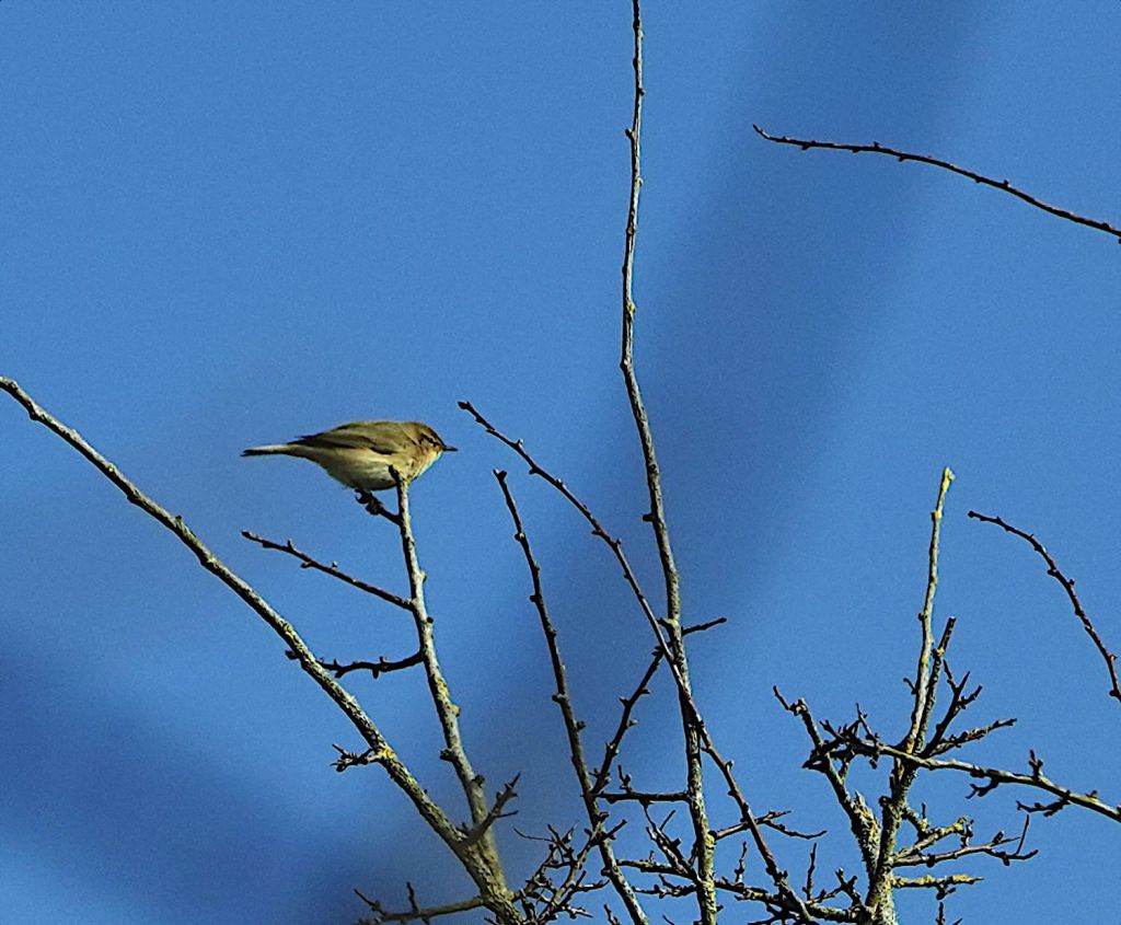
Not my finest photograph ever, but this was the first Chiffchaff I saw this year (though not the first I’d heard)
After crossing the river again (the Avon splits around the mill), not long after a sharper bend to the right, I climb a stile and follow a footpath that leads to an old disused railway track. The path crosses a field, and I see butterflies – a Brimstone and a Small Tortoiseshell – awake from hibernation and flitting in the sunshine.
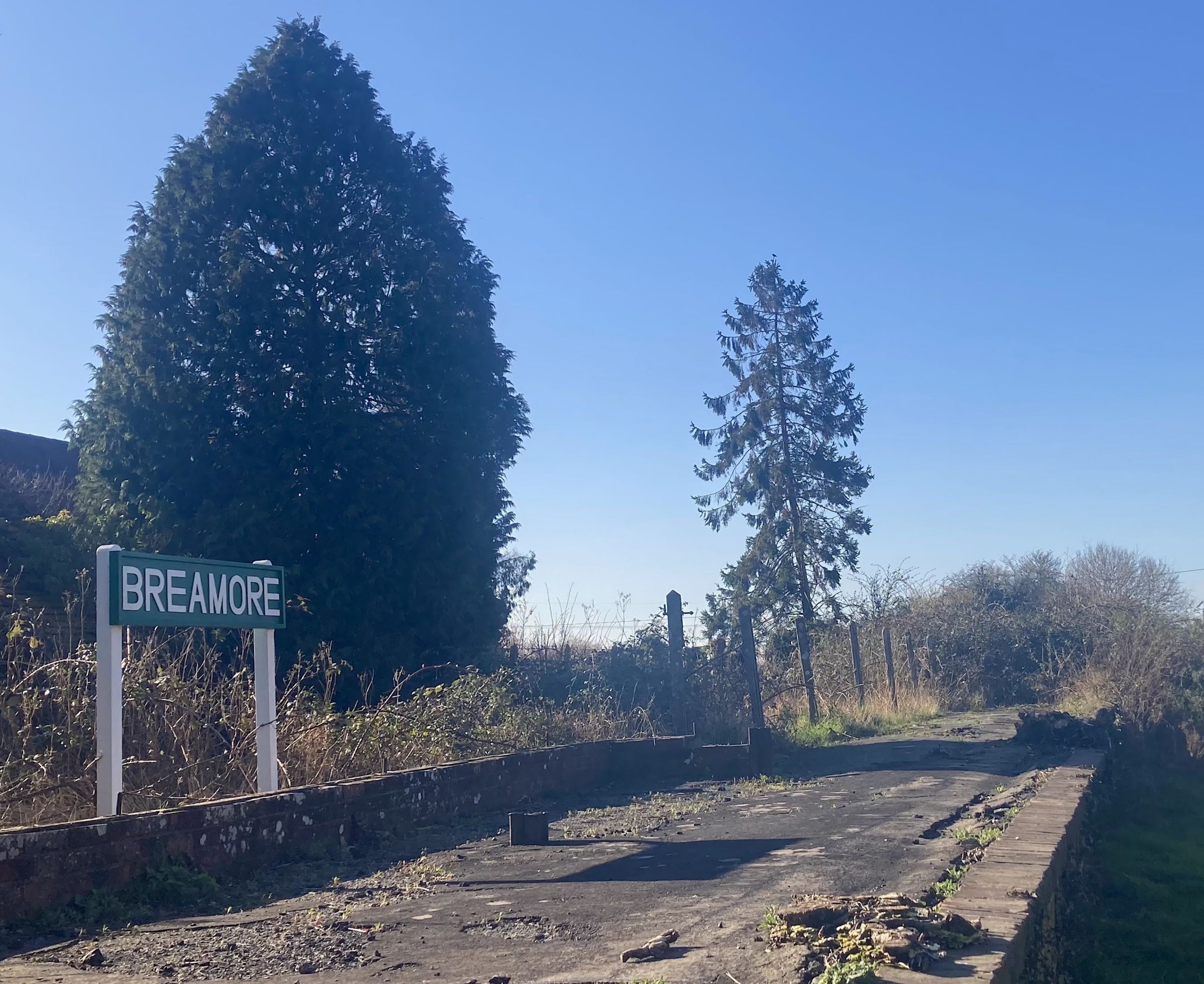
Breamore Station and the disused railway track
I pass through a small wooden gate and climb down on to the disused railway track. The main Salisbury Road is not very far, and I can hear the traffic, but this is still a place of nature. Chiffchaffs are calling everywhere. The sun is bright on the budding trees, and the gentlest of breezes ruffles my hair.
I am standing on is what is left of the single-track 18-mile railway line that once carried trains between Salisbury and West Moors. Opened in 1866, the Salisbury and Dorset Junction Railway was finally closed in 1964. Here, a two-mile stretch has been reclaimed as a footpath, running from Burgate, a little further south, to South Charford. The point where I have joined it is close to Breamore Station, where the buildings survived and have been restored. Five homes have been built on one of the platforms, and the line of the railway track runs behind them. A football goal has been set up along the track, so there are railway children living here.


When Joan was walking in these parts, back in the 1930s, the railway would still have been running. I wonder if she ever used it, to travel to Salisbury, maybe. I imagine a train chuntering by, Joan’s open, good-hearted face gazing out of the window at the fields and trees. Perhaps, looking out, she would have seen me, a ghost of the future, a woman with binoculars and curly hair lifting a hand in greeting as she passed by.
The footpath that was once a railway is lovely. A grassy track, edged by long tumbles of willows and bramble, with fields and streams and the river beyond, heads straight northwards. Rooks are cawing and squabbling overhead, and the ground beneath is crunchy with twigs fallen from the rookery nests. Willow catkins are bursting on their branches into feathery softness. A Peacock butterfly, wings a little frayed after its hibernation, lands on the path ahead of me, and basks in the warmth of the sun.

I want to see if I can reach a field where a mediaeval Augustinian Priory once stood. The priory is associated with the Breamore Mizmaze, already mentioned, which lies about two and a half miles away. It was probably the Canons who cut the Mizmaze, and who walked there from the priory to tread the spirals of the maze in penance. I’d visited the Mizmaze, the end of their little pilgrimage, and wanted to see if I could find its beginning. The OS map shows a path (but not public) that leads from the disused railway line to the edge of the field where the Priory once stood, but it is barred by a padlocked gate. Nonetheless, I stand here for a few moments, imagining the Canons walking towards me in sandalled feet and long robes. Would they have been silent? Or would they have been murmuring cheerfully to each other as they walked through the grass and wildflowers, listening to the Chiffchaffs?

I walk on, and it is not long before I reach the end of the disused railway line, to the northwest of South Charford Farm. I turn right here down a rough and ready track towards the water meadows, but not before I have looked back along the old railway line, full of memories, life, and crossed by the adventures of pilgrimage and voyages through long ages.
Next week, I’ll be continuing the walk, crossing water meadows and, once again, the Avon as it winds its slow way to the sea.


I too felt a thrill of anticipation, reading your lovely descriptions of Spring, bursting out all over! We can see hopeful signs, but we’ve got a bit to go before we reach the delights you describe! This walk was a real treat…..and I loved the warm haziness of your photos! I must look up this Mizmaze….it sounds fascinating!
LikeLiked by 1 person
Spring is wonderful – but then so are all seasons! The Breamore Mizmaze is a very serene, mystical place. A good spot for contemplation.
LikeLike
I have walked your route accidentally when I missed a sign for a section of the Avon Valley Path a few years ago. I did not know about the Augustinian Priory and Mizmaze – I shall have to research them. Your writing brought this section back to me, all the Spring sights and sounds and the cacophony of birdsong from all sorts of Warblers when I walked along the twin bridges stretch.
LikeLiked by 1 person
The Mizmaze is wonderful! I walked up to it at Bluebell time last year, and the woods through the Breamore Estate were beautiful. The Mizmaze itself is magical. Great views from the top of the hill, too. I walked the Avon Valley Path from Fordingbridge to Downton on a hot August day a few years ago and got lost at least twice! – I’m not sure the signage is that good in a few places…! – but it’s a lovely route.
LikeLike
A peacock butterfly was the first butterfly I saw this year, just a couple of days ago. Since then, they’re everywhere. Amazing, the difference one warm week makes in my neck of the woods. I love looking at your nature pictures – they are like promises for me… things to look forward to in a few weeks’ time.
LikeLiked by 1 person
It’s so lovely seeing the butterflies on the wing in spring! 💚🦋
LikeLiked by 1 person