In which I walk through meadows of grass and water, and greet the Guardian of the Avon
…Charford…a scattered parish, whose claim to fame is the beautiful water-meadows lying between the Salisbury and the Hale roads. They are enchanting now with their countless streams, tiny weirs and bridges, their long grasses and pollard willows, but once they were a stretch of treacherous marshes deep in rank reeds.
Joan Begbie, Walking in the New Forest, pub. 1934
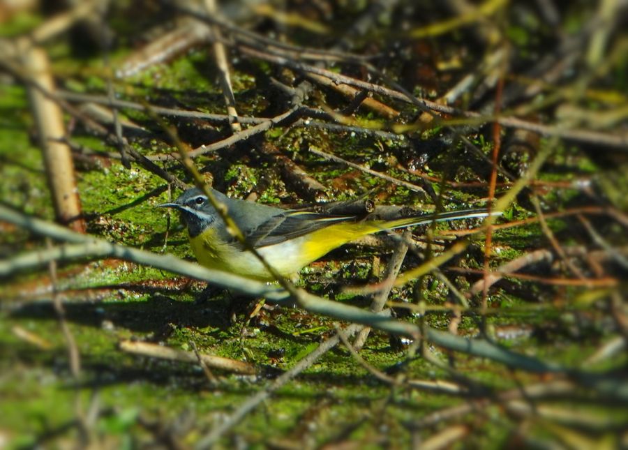
This week, I’m continuing a circular walk from Woodgreen. At the end of the last post, we found ourselves at the northern end of all that remains of the disused Salisbury to West Moors railway line, closed since 1964. We had heard Chiffchaffs, seen Brimstone, Peacock and Small Tortoiseshell Butterflies, and brushed our fingers against the softness of Willow catkins. Now, we are heading for something different – the water meadows that lie between the Salisbury and Hale roads, around North and South Charford.
Regular readers of this blog will know that I am following walks, or parts of walks, described by Joan Begbie in Walking in the New Forest. I’m interested to discover what has changed and what has not in the Forest, as I walk alongside Joan and her two characterful dogs, Bill, a white bull terrier who loves to charge out of sight across the heaths, and Mr. Bundy, “a rough-haired brindled griffon of diminutive size and choleric disposition”. This time, I’m walking through some places that Joan visits or describes, but not as part of one of her long walks.
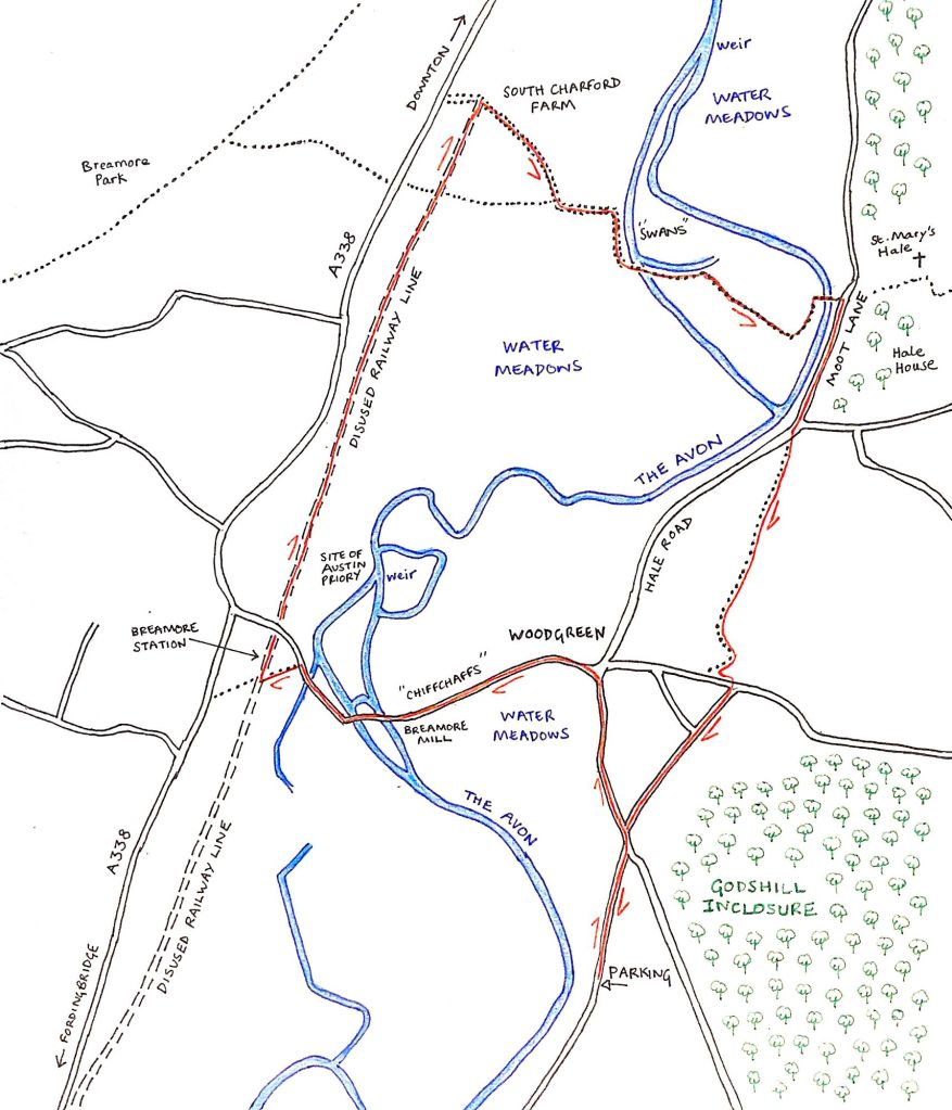
The water meadows of the Avon
I’m not sure if these water meadows have changed much since Joan was walking in this part of the Forest. Still criss-crossed by water channels fed by the Avon, the meadows seem ancient. I thought I may find them unbearably boggy, but the paths are, on the whole, good (not to say there aren’t some muddy patches), thanks to the recent dryer weather. The meadows are, of course, part of the Avon catchment, and ditches criss-cross the flat, low landscape, draining the fields. What are water meadows? Originally, the fields would have been deliberately flooded, but in a controlled way; the presence of water early in the year allowed the grass to grow earlier by protecting the roots against frost; in turn, animals could be put out into the fields to graze earlier. The water meadows along this part of the Avon date from the seventeenth century.
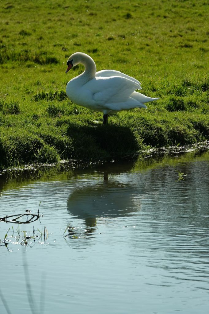
First, though, I make my way past South Charford Farm, negotiating puddles and mud (this is a working farm – I’m not complaining!). Then I follow the footpath across a squelchy field, before turning sharp right, following a hedgerow that separates the path from a larger channel heading towards the Avon. There are swans here: I spy them through the vegetation, sitting by the bank, preening their feathers.
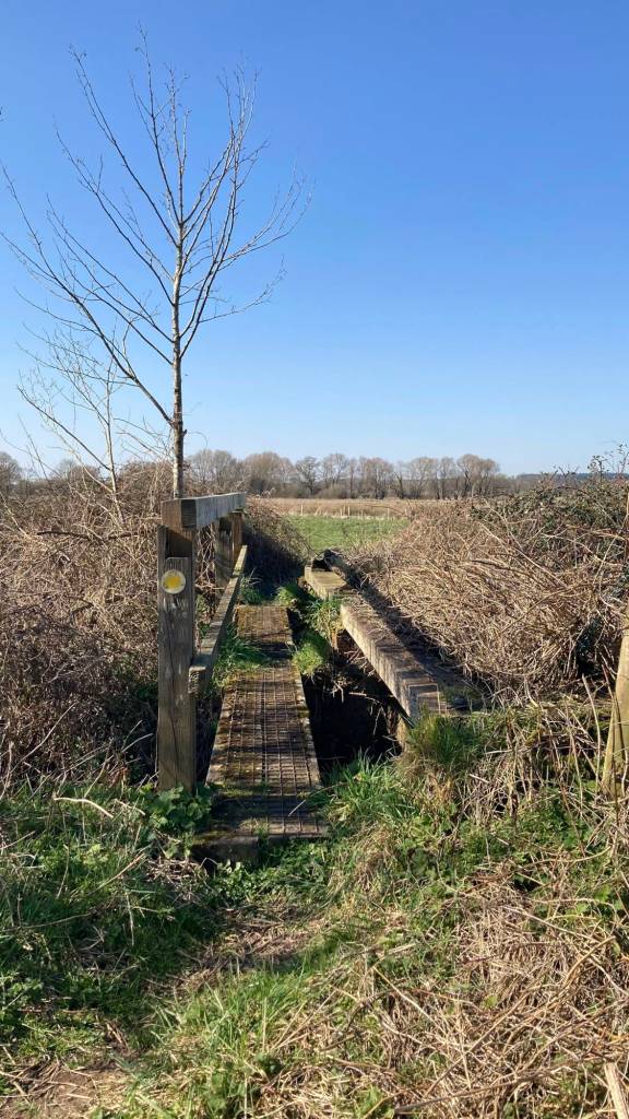
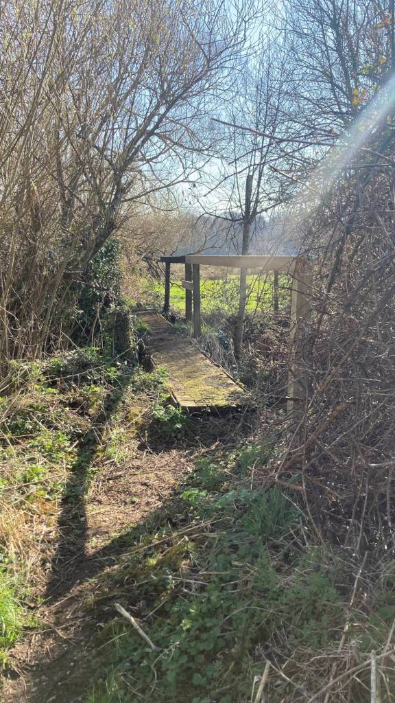
After this I turn left and I’m in the midst of the water meadows proper. This is a world of tree- and shrub-lined water channels, rough paths and old stiles and footbridges. Some of the footbridges require bravery to set foot on, but they are all stronger than they look (although one did end up in the middle of a bramble thicket – fortunately it was possible to hop off sideways). Anyway, in this historic landscape, who would want modern-looking structures of metal and concrete?


Cerdic’s Ford
The water meadows are part of the Avon’s floodplain and, before the flooding was controlled to create the water meadows, the area would have been boggy and watery; “a stretch of treacherous marshes deep in rank reeds”, Joan reminds me. They have a long history.
The name Charford is derived from Cerdic’s Ford, which is mentioned in the Anglo-Saxon Chronicle. In the Chronicle, Cerdic is referred to as a Sixth Century Anglo-Saxon leader and founder of Wessex. These origins are disputed, as is his ethnicity: the name Cerdic is very possibly Brittonic rather than Anglo-Saxon. I think we can leave this to the historians to dispute. However, the story in the Chronicle goes that he fought native Briton forces at Cerdic’s Ford (i.e. at Charford) in 519CE [AD], and won. The more mythological telling of this tale, which is described by Joan, goes that the leader of the Britons was Ambrosius Aurelianus, who was killed at the Battle of Cerdic’s Ford with 5,000 of his men. Ambrosius, the legend says, was the father of King Arthur. Joan learned this story from the writing of John Richard de Capel Wise:
…Wise, from whom we got our information, does not say whether the prince [Ambrosius Aurelianus] was given burial or whether the victors left him where he fell. We rather hope they left him, because it is tremendous to think that here in this green valley King Arthur’s sire lies.
Joan Begbie, Walking in the New Forest, 1934
It may be fanciful, but I too would like to think the mysteries of myth and legend lie beneath my footsteps as I walk through the water meadows.
Hale
In the end, the water meadows meet the road coming down from Downton. Here, I cross a bridge across the Avon (a sturdy concrete and metal-railed affair this time). There is a pair of Grey Wagtails bobbing and bowing at the water’s edge.

On the other side of the bridge, a footpath heads up to the pretty church of St Mary’s, Hale. I don’t go that way, instead turning right down Moot Lane, which is, here, on the Avon Valley Path, a long-distance walking route from Christchurch to Salisbury.

Back to Woodgreen
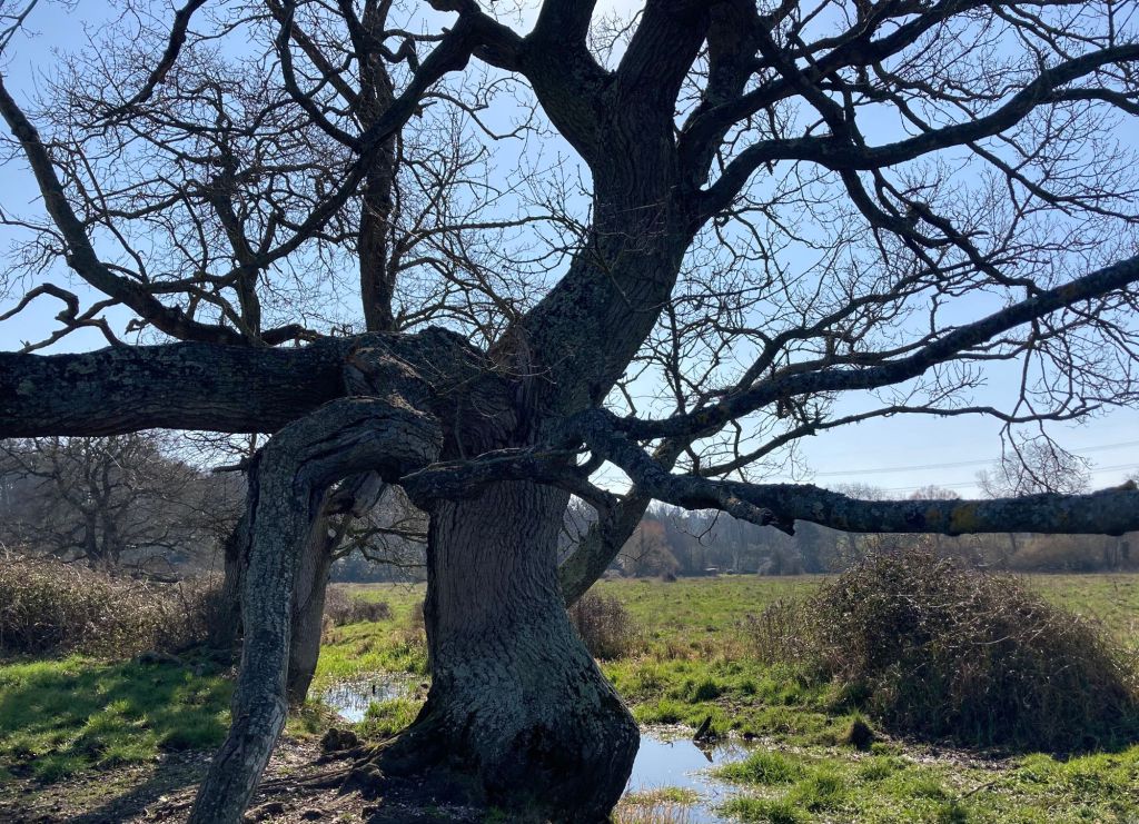
Moot Lane is quiet – I know it’s Sunday, but this is not a very busy road, so I never mind walking along its tarmac. To my left, the meadows of Hale Park are brimming with Daffodils, Wood Anemones and Primroses. On my right, not long before the southern end of Moot Lane, I greet an old friend. This is a tree, hollow, sawn off at its top, that stands sentinel over the Avon on its opposite (western) bank. A rope hangs from it and there’s a rope hanging from a tree on my side of the river, too. I wonder how many games of how many children this old Guardian of the Avon has seen in its long life?

When Moot Lane meets Hale Road, I turn off left, continuing along the Avon Valley Path. In the field ahead, a Thrush hops through the grass, and a Red Admiral butterfly – awoken by the sun from its winter sleep – flies by in dips and curves. After passing over a stile by a gate, the way follows roads and paths through the eastern edge of Woodgreen, and eventually I find myself back on the road to Castle Hill, where I started this walk. The trees of Godshill Wood whisper to me over the boundary fence, and flecks of light sparkle over the grass.
At Castle Hill, I spend time lost in the view from this high place, reaching over the valley and chalk hills beyond. This has been a walk of woods, hedges, water meadows and a slow river meandering through the landscape, and of the creatures and plants that live there.
As I leave, a Chiffchaff calls. Chiffchaff chiffchaff. Come back, come back.
I’m going to be travelling in April, and I’ve decided to pause my walks with Joan, Bill and Mr Bundy until I return at the start of May. With spring bringing its annual awakening to the New Forest, I can’t wait to be walking with Joan and the dogs once more and sharing our time together with you here. See you all in May!

Walked this yesterday, 28/9/24 – the railway track from Breamore has become almost impassable half way along and at the farm totally impassable needed to climb a locked gate to join the Avon valley path. Although the river was not in flood the water meadow had deep water, so don’t be caught out by the river levels appearing o.k
LikeLike
Oh dear – I haven’t walked that way in a while. I hope you made it without too much bother and water 😬
LikeLike
I came through dry as I had over knee boots, my two companions had wellies and got soaked but we all still enjoyed the walk
LikeLike
Hello, I very much enjoyed this piece. It is an area I visited frequently for a number of years. The view from Godshill looks upon the river at ‘Folds farm’ where I used to fish. Similarly, half way along moot Lane is ‘Searchfield farm’ . The river there used to be leased by Salisbury AC and extended from just above Hale weir to the disused railway line. I spent many long spring and summer days at this section watching cuckoo’s , the occasional barn owl and otter. Rarely did I encounter anyone else. Sadly, this magical section has not been accessible since the new owner and the angling club could not agree to terms.
Thanks for the enjoyable reminiscences.
LikeLiked by 1 person
What a lovely comment and memories of nature! It’s such a shame about the access – I hadn’t realised that stretch had been accessible previously. It’s always wonderful to find ‘secret’ spots that few know about, and I hope you have found some more!
LikeLike
Do you know, one other thing, among the many that are so refreshing in your writings, is you puncutation! Nothing frustrates me more in “young” publications of all kinds these days, that punctuation is not used. It can make such a difference to the meaning of the prose, and slows my reading of a piece down. Thank you for that…it’s our age I guess ;-). I have done this walk the other way around, so lovely. I love the idea that we have a King Arthur style legend in our area.
Have a wonderful time away and look forward to hearing more in May, Gail x
LikeLiked by 1 person
Thank you, Gail – it’s a lovely walk and not one I’d done before. I think I’ll be doing it again. I so agree about punctuation and how it alters the reading of a piece, and it’s good to know there’s a fellow thinker out there!
LikeLike